This 7 day Norway itinerary covers the north-western Norwegian fjords region visiting iconic places such as Jostedalsbreen National Park, Lovatnet, Girangerfjord, Ålesund, the Atlantic Road and Åndalsnes. See towering fjords and massive glaciers, join a midsummer festival, and hike spectacular trails along this unforgettable road trip. and other points of interest, as well as wild camping locations.
The itinerary is based on a trip taken by campervan in June. Hiring a campervan or camping in general is a budget friendly way to visit Norway as you can save hundreds on accommodation and food.
You may also be interested in our other guide: ‘Visiting Lofoten in winter’.
Norway itinerary route
This Norway itinerary begins in Jostedalsbreen National Park, before heading north to beautiful Lovatnet lake, then on to world famous Girangerfjord, the seaside town of Ålesund, the iconic Atlantic Road and then to the outdoor recreational heaven of Åndalsnes.
To get to this area of Norway we recommend starting in Bergen, Oslo, or Trondheim and renting a car/campervan from there. The drive times are long but the scenery along the way is beautiful passing mountains, glaciers, rivers and countryside.
Drive times:
- Bergen to Jostedalsbreen: 5-hours.
- Oslo to Jostedalsbreen: 7-hours.
- Trondheim to Åndalsnes: 4.5-hours.
Some routes incorporate toll roads and ferries to take you from one side of a fjord to the other.
If you would like to spend time in Bergen, Oslo, or Trondheim, we recommend adding another day to your trip.
If you are starting from Trondheim, we recommend doing this itinerary in reverse beginning in Åndalsnes and finishing in Jostedalsbreen National Park.

Day 1: Jostedalsbreen National Park/Nigardsbreen Glacier
On day 1 of your Norway itinerary, start early and make the long drive from Bergen or Oslo to Jostedalsbreen.
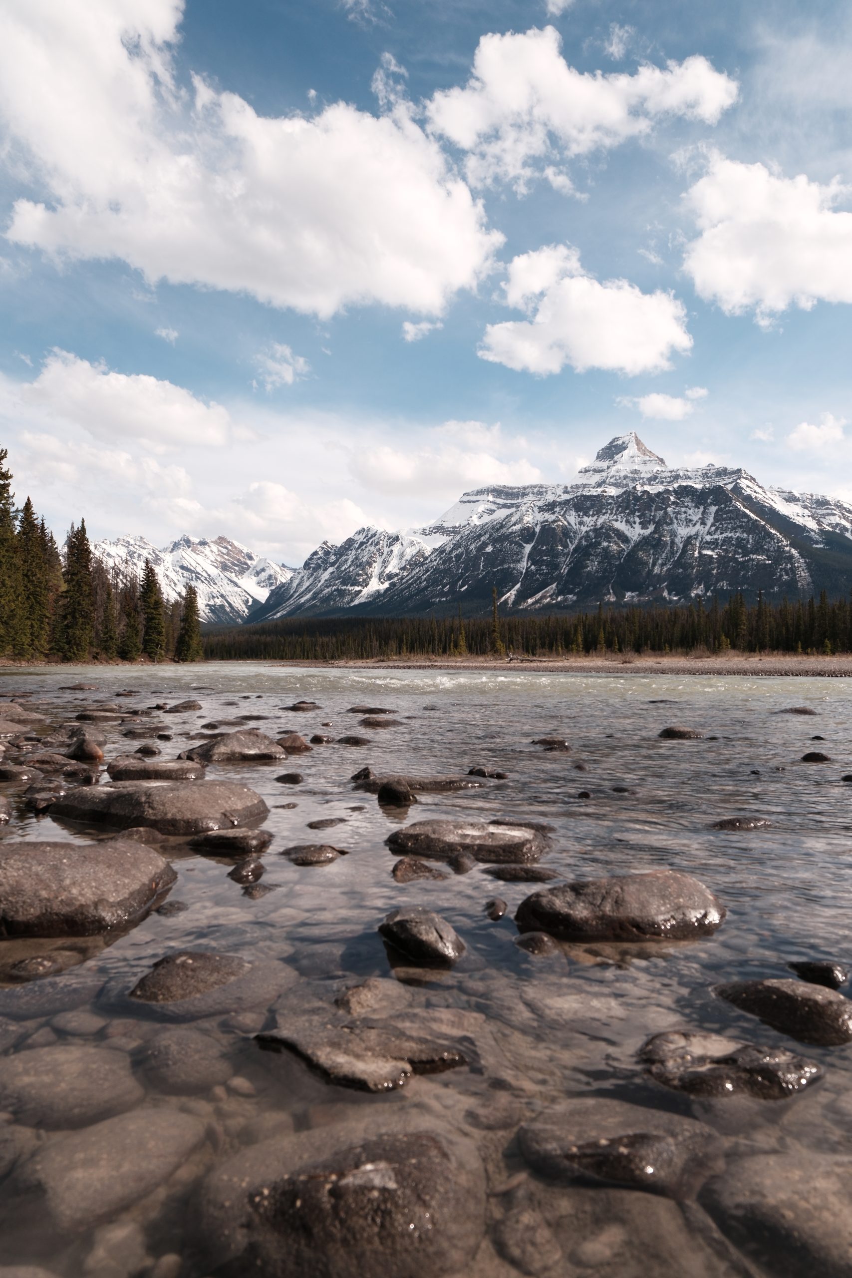
Jostedalsbreen National Park is an expansive protected area that encompasses the biggest glacier in mainland Europe, the Jostedalsbreen glacier. Nigardsbreen glacier is an arm of this large glacier and is one of the most accessible glaciers in Norway where you can hike very close to it or join a guided walk.
Nigardsbreen glacier hike:
A relatively easy, 45 minute one-way hike to view the glacier up close that can be done without a tour guide. At certain points along the hike you will need to scramble over rocks so good walking shoes are recommended.
- To reach the footpath that takes you to the glacier, take the toll road signposted to Nigardsbreen glacier until you reach the car park.
- Follow the trail from the car park that takes you along the lake shore. (An alternative way of reaching the glacier is by ferry from the car park which links up with the footpath halfway.)
- You will reach a viewpoint of the mouth of the glacier and from here you can walk further along the rocks to get closer.
Guided glacier walks can be booked here.
After visiting Nigardsbreen glacier, head towards Stryn (around a 3-hour drive) where you will next visit Lovatnet. The route there will take you around Jostdalsbreen National Park as, unfortunately, there is no direct road through, however like all the drives in Norway the road is very scenic and you will pass more glaciers, as well as lakes, mountains, and valleys.
There are several good campsites at Lovatnet, but if you would like to camp overnight along the way we recommend Vatnaste Rastplass which is located along a lake and has toilet facilities and picnic benches.

Day 2: Lovatnet and Geirangerfjord
Spend the morning at Lovatnet – one of the most beautiful lakes in Norway known for its turquoise, clean, and reflective water. Go for a leisurely walk along the lake, a bracing swim, or find a spot for a very scenic picnic. Alternatively, you can rent rowing boats or kayaks from activity centres located along the lake.
From Lovatnet drive just under 3 hours to Geirangerfjord – Norway’s famous and iconic fjord. This UNESCO protected area is home to waterfalls, snowy mountain peaks, and incredible views. About 10 minutes before you reach the town of Geiranger stop at the Flydalsjuvet Viewpoint that offers a beautiful outlook overlooking the fjord. Geiranger welcomes huge cruise ships that sail through the fjord and stop at the town, so in summer it can get quite crowded. However, go for a hike or take a kayak to explore the fjord and you will have a little piece of this beautiful Norwegian destination all to yourself.
Spend the afternoon or even evening (because there are endless hours of daylight in summer) hiking to the beautiful Skageflå.
Skageflå hike:
Skageflå is a mountain farm 250m above the Geirangerfjord that offers exceptional views of the fjord and the waterfalls cascading down the cliffs. It can be accessed by a moderate hike from Geiranger that is approximately a 4/5-hour round trip.
- Start in Geiranger and follow the road around the fjord to Homlong. The trailhead begins from here.
- The route takes you up over a rocky area and then into a forest where you will have great views across the fjord. After about 1.5 hours you will reach an alpine pasture. From here follow the path to Skageflå for the incredible view.
- You can either take the same route back to Geiranger or follow the path that descends steeply down the mountain to Skaghola, and from there you can get a ferry to take you back to Geiranger. Information about the ferry can be found here.
(Alternatively you can catch the ferry there and back or do the route in reverse by first taking the ferry and hiking back to Geiranger).
For an overnight stay, tents can be pitched at one of the campsites located along the fjord near Homlong or campervans can park up along the minor road between Geiranger and Homlong.

Day 3: Geirangerfjord and Ålesund
First thing in the morning, head to the Geiranger Kayak Centre and rent a kayak for a couple of hours to explore the fjord by water and get up close to the magnificent waterfalls cascading down the side of the steep cliffs. The fjord is generally sheltered and calm so beginner kayakers shouldn’t worry.
Once you’ve said goodbye to Geirangerfjord, start your 2-hour journey to the town of Ålesund. This port town lies on the west coast of Norway amongst a series of islands. The town is often named the most beautiful in Norway for its colourful buildings and surrounding landscape.
If you are here around the summer solstice then be sure not to miss Ålesund’s midsummer celebration which includes the largest bonfire in Norway, standing at over 100 feet tall. Bonfires are a tradition in Norway to mark the longest day of the year. To light this giant bonfire local residents climb, yes climb, to the top to light a barrel, they then rapidly descend as the tower starts to burn.
We advise making the most of being in a town and spending a night in a hotel.

Day 4: Atlantic Road and Åndalsnes
Make your way around the coast today to the Atlantic Road (under a 3-hour drive from Ålesund). This is a scenic coastal road with a series of bridges linking islands with lots of viewpoints. Our recommendation is to only visit the Atlantic Road if the weather is fine. It’s pretty miserable if it’s raining and foggy.
From the Atlantic coast, head back towards the mainland to Åndalsnes and the Romsdalen Valley, the outdoor capital of Norway and home to spectacular scenery. The journey takes just under 2-hours, and you will probably want to stop lots along the way to take in the incredible landscape. There isn’t too much to see in Åndalsnes but it’s worth making a trip to the visitor centre to get an idea of all the things you can do in the area and perhaps grabbing a bite to eat in the café.
There are lots of nice campsites in the surrounding area or make your way down the E136 towards Trollveggen and you will find a minor road running alongside the river which you can pull over on and stay the night. We found that many of the smaller roads in this area do say ‘no overnight camping’ so be sure to double check.
Day 5: Romsdalseggen
The Romsdalen Valley has many fantastic hiking trails to choose from – one of the best is the Romsdalseggen hike which incorporates the Rampestreken observation deck 500m above Åndalsnes and the Romsdalseggen Ridge. It has been named as one of the most beautiful hikes in the world.
Romsdalseggen hike:
This hike ascends close to 1000 meters and is somewhat challenging due to steep inclines and a narrow ridge. However, those who are up for it will be rewarded with breath-taking views of the valley, fjords, and on a clear day, the Norwegian coastline. The route takes you from one point to another – you can choose to do just part of the route of the full route takes around 6 hours.
- The trailhead begins in Venjesdalsetra. You can catch the dedicated Romsdalseggen bus from the tourist information centre in Åndalsnes.
- The bus will drop you off and from here you will start your ascent to the ridge. When the path forks take the left to the ridge rather than a detour around it. The ridge may not be suitable to cross for those with a fear of heights or young children as it is quite narrow in some parts with a steep drop either side. If you are lucky enough to do the hike on a sunny day, the view from here down to the valley is really magnificent.
- Once you have crossed the ridge you will reach a plateau which you will need to continue along for another hour. As you reach the end of the plateau you will have a 360 view.
- From here the route will begin to descend across uneven rocks until you reach the Ramestreken observation deck with a view down to Åndalsnes and the valley.
- From the viewing deck its about an hour down a very steep and uneven path to Åndalsnes.


Day 6: Trollstigen and Trollveggen
On day 6 of your Noway itinerary, spend some time exploring the area further and visiting two iconic Norwegian places.
Trollstigen (the Trolls Road) is a winding mountain road that if seen from a certain angle can appear almost vertical. The drive up and down can be slightly nerve-racking as you look over the edge to see a steep drop. At the top of the road is a visitor centre and observation deck.
Back down in the valley is Trollveggen. This is Europe’s tallest vertical rock face and from the bottom of the valley you can see why it has been named the Troll Wall. The sheer size and height of it looms over the valley. It’s an incredible sight to see.


Day 7: Return home
Spend your final morning in Romsdalen Valley, then begin your journey home.